What is NASA Harvest?

We are NASA’s Global Food Supply and Agriculture Consortium
Our Impact Areas
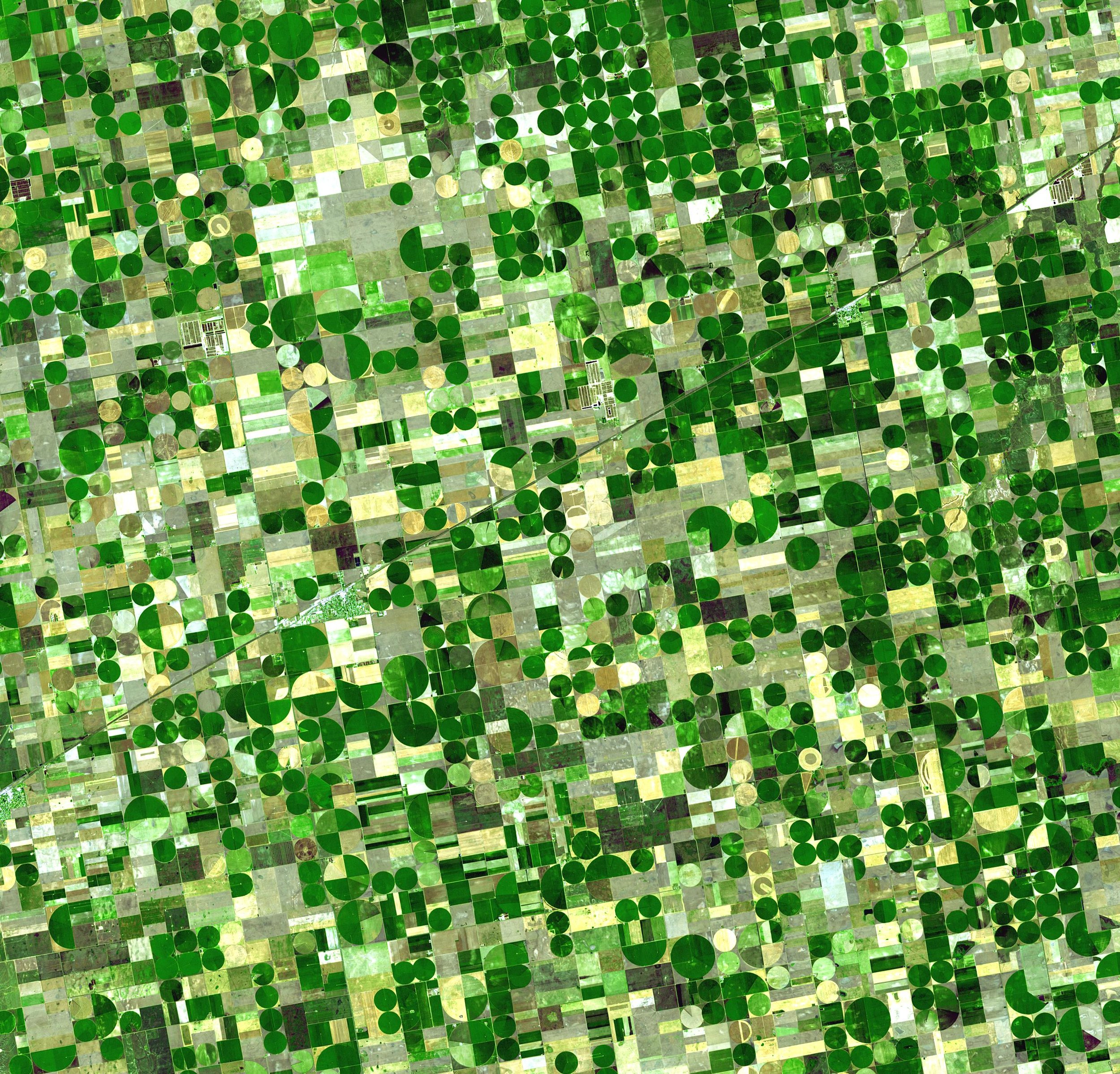
In the face of growing populations, unpredictable weather, food supply disruptions, and market volatility, the NASA Harvest Consortium leverages Earth observation data and public-private partnerships to provide timely, actionable insights that enhance U.S. and global agricultural resilience and informed decision-making.
-
We provide actionable agricultural assessments in the face of increasing frequency and severity of extreme weather events, conflict and war, supply chain disruptions, market uncertainty and other unforeseen events and disasters that impact crop production, trade, access, and ultimately food supply.
-
We promote market stability by producing and disseminating accurate and timely agriculture information regarding crop health, crop production, environmental and weather disruptions, socioeconomic risk factors, and import/export logistics.
-
Risk assessments for agriculture involve analyzing the potential impacts of weather and ecosystems on food production, including crop yields. Satellite data helps us identify vulnerabilities and inform adaptive strategies. By evaluating these risks, farmers and policymakers can develop plans to mitigate adverse effects and enhance the resilience of agricultural production.
-
Agricultural losses have substantially increased in the past 30 years due to extreme weather events - smallholder farmers are particularly vulnerable given their strong dependence on weather-driven agriculture for their livelihoods. Satellite data can help inform financial instruments, such as agricultural insurance, in playing a key role to reduce vulnerability and increase farm resilience.
-
Early warning and preemptive planning are critical for effective prevention and mitigation of crop failures. Satellite data play a key role in providing timely insights on crop conditions globally, enabling decision makers to effectively determine needs for ensuring food needs are met.
-
Some key challenges to the uptake of satellite-derived information include access restrictions, inconvenience, difficulty of use, and lackluster automation. Our consortium framework enables us to work collaboratively across the agricultural sector and with the private sector in order to build accessible tools, ensure secure data sharing, and integrate with existing systems.
-
Monitoring nitrogen fertilizer uptake using remote sensing data involves analyzing spectral signatures from satellite imagery to assess plant health and nutrient levels. This technology enables more precise detection of nitrogen levels in crops by observing variations in vegetation indices. This approach allows for efficient, timely adjustments to fertilizer application, optimizing crop yield, lowering costs, and reducing adverse impacts.
-
Our special initiatives are driven by the global nature of our existing agri-food systems. By studying innovative farming practices, technologies, and policies from other countries, we can adapt and apply valuable insights to strengthen U.S. agriculture, improve resilience, and ensure food supply.
G20 GEOGLAM
The purpose of Group on Earth Observations Global Agricultural Monitoring Initiative (GEOGLAM) is to increase market transparency and improve food security by producing and disseminating relevant information on agricultural conditions and outlooks of production at national, regional, and global scales. Harvest supports GEOGLAM through various community-driven efforts including production of GEOGLAM’s monthly Crop Monitor reports.
Harvest Africa
One of our unique geographically-focused impact areas, Harvest Africa leverages world-class technical expertise across Africa. This initiative advances innovative satellite-driven methods to produce automated within-season crop type and crop-specific condition products that support agricultural assessments, directly involving national and regional agencies in the development process to ensure smooth transition to the respective community.
Harvest Latin America (LatAm)
NASA Harvest Latin America is a regional initiative dedicated to advancing agricultural monitoring, enhancing food supply, and farm resilience approaches across the Latin American region. Our vision is to leverage satellite technology, data-driven insights, and local expertise to empower communities, foster collaboration, and develop innovative tools that support informed decision-making - all of which can be applied in other regions around the world.
Harvest South Asia
Much like our other regional initiatives, Harvest South Asia focuses on satellite data applications specific to the unique agriculture and food availability challenges of South Asia. From analyzing the impacts of drought and flooding on rice cultivation to addressing cloud coverage challenges, this initiative leverages top technical expertise across South Asia to develop innovative, satellite-driven analyses.
Harvest Agricultural Statistics
Agricultural statistics are crucial for effective policy-making as they provide accurate data on crop production, food availability, and resource use, enabling governments to make informed decisions. These statistics help identify trends, forecast food supply, and address other agricultural production issues. By relying on robust agricultural data, policymakers can design targeted interventions that support agricultural growth and economic stability.

NASA Harvest in the News
-
![]()
Assistant Professor Catherine Nakalembe Named Public Voices Fellow
November 11, 2025
-
![]()
New Research Shows How Farmers Can be Left Dry by Rainfall Insurance
October 31, 2025
-
![]()
UMD-Led Team to Create New International Center for Rapid Agricultural Assessments
October 7, 2025
-
![]()
NASA Scientist Starts Food Crisis Hotline With Tech Giant Funding
September 17, 2025
-
![]()
A Ukrainian Farmer Fought Back Against the Russians. He Paid With His Life.
September 9, 2025
-
![]()
Assistant Professor Catherine Nakalembe Named Public Voices Fellow
September 9, 2025
-
![]()
NASA Releases Galileo: The Open-Source Multimodal Model Advancing Earth Observation and Remote Sensing
August 4, 2025
-
![]()
A CAREER in orbit Hannah Kerner receives prestigious NSF award to power purposeful planetary insights
July 10, 2025
-
![]()
The Future of Agriculture Includes Satellites and AI: 5 Lessons Learned from the 2025 LEAD Maryland Workshop
May 7, 2025
-
![]()
Agmatix CEO Ron Baruchi on How Harnessing the Power of Data Modeling Will Transform the Future of Crop Inputs
April 18, 2025
-
![]()
Agmatix + NASA Harvest: Leveraging Remote Sensing to Scale Regenerative Agriculture
March 31, 2025
-
![]()
NASA Harvest and Partners Strengthen Agricultural Monitoring in Ethiopia
Feb 4, 2025
-
![]()
Using AI and Satellite Data to Transform Agriculture: A Conversation with Alyssa Whitcraft
Dec 18, 2024
-
![FAO logo]()
Zambia: El Niño Impact Assessment Highlights
December, 2024
-
![]()
NASA’s Brad Doorn Brings Farm Belt Wisdom to Space-Age Agriculture
Nov 20, 2024
-
![]()
GEOG Assistant Professor Recognized in Ceremony at Kuwait's Royal Palace
Dec 18, 2024
-
![]()
A Personal Journey with Earth Observations: The Future We Are Cultivating
Nov 18, 2024
-
![]()
Zambia: El Niño Impact Assessment Highlights
Oct 6, 2024
-
![]()
Can Space Data be the Catalyst for a Revolution in Food Production?
Oct 1, 2024
-
![]()
Mathematica and NASA Harvest Partner to Advance Evidence for Climate Adaptation
Aug 15, 2024
-
![]()
Harvesting data from space to inform policy predictability and investments in Ukraine’s grain sector
May 28, 2024
-
![]()
NASA Harvest, the University of Maryland, and IICA present a joint study that surveys and promotes the use of remote sensing to develop agricultural statistics in Latin America
May 20, 2024
-
![]()
Southern Africa Hit with Driest February on Record in Central Areas
Mar 24, 2024
-
![]()
Mapping Water Availability Across Africa
Mar 6, 2024
-
![]()
General Mills and Unilever Join Forces with the Harvest Initiative to Advance Sustainable and Regenerative Agriculture Practices Worldwide
Feb 13, 2024
-
![]()
AI can deliver broad benefit from our data deluge
Jan 30, 2024
-
![]()
When Farmland Becomes the Front Line, Satellite Data and Analysis Can Fight Hunger
Jan 22, 2024
-
![]()
Postdoctoral Associate Abdul Qadir Awarded Robert N. Colwell Memorial Fellowship
Jan 18, 2024
-
![]()
Out-of-this-world technology supports agricultural insurance initiatives with NASA Harvest partnership
Jan 15, 2024
-
![]()
American Geographical Society Elects Catherine Nakalembe to AGS Council
Dec 29, 2023
-
![]()
Ukraine’s Lost Crops: An 8 Million-Ton Black Hole in World Stats
Dec 20, 2023
-
![]()
Ocean Warming Sets the Stage for Dangerous but Predictable East Africa Droughts
Dec 6, 2023
-
![]()
'Charity is not a solution to food insecurity': How to feed the future
Nov 29, 2023
-
![]()
Over one hundred women involved in agriculture and natural resource management in Costa Rica strengthened their digital and geospatial technology skills at IICA Headquarters
Nov 20, 2023
-
![]()
From the Soil to the Stars
Nov 13, 2023
-
![]()
The Board of Trustees of the Al-Sumait Prize for African Development announces the award winners for the year 2022 - Africa.com
Nov 6, 2023
-
![]()
The Board of Trustees of the Al-Sumait Prize for African Development announces the award winners for the year 2022
Nov 6, 2023
-
![]()
Egg-citing Finding on Future Food Prices
Oct 24, 2023
-
![]()
Karamoja Beset with Drought
Oct 23, 2023
-
![]()
Climatic stresses and rural emigration in Guatemala
Oct 11, 2024
-
![NPR log]()
The bruising artillery battle in Ukraine has left a scar that is visible from space
Oct 6, 2023
-
![]()
Tackling Food Insecurity: From Emergency to Resilience | The Development Podcast
Oct 1, 2023
-
![]()
GEOG's NASA Harvest Team Receives Award For Monitoring Impact of War on Ukraine’s Agriculture
Sept 22, 2023
-
![Arrell Food Institute Logo]()
Winners of 2023 Arrell Global Food Innovation Awards Announced
Sep 20, 2023
-
![Via Satellite logo]()
Satellite Plants Roots in Agriculture
Aug 28, 2023
-
![AMIS logo]()
Destruction of Ukraine's Kakhovka Dam Spells Trouble for Regional Agriculture
Jul 6, 2023
-
![]()
FEWS NET Scientists: Entire Ukraine Canal System Vital for Farm Irrigation ‘Dried Up’ After Dam Breach
Jul 5, 2023
-
![]()
The Collapse of the Kakhovka Dam Seen from Satellite Imagery
Jul 4, 2023
-
![Forbes Argentina logo]()
An Argentine Startup Partners with NASA Harvest to Monitor Crops in the Region
June 29, 2023
-
![]()
Ukraine dam: Satellite images reveal Kakhovka canals drying up
June 22, 2023
-
![NASA Earth Observatory logo]()
A Rough Harvest for Kansas Wheat
June 22, 2023
-
![Nat Geo logo]()
Ukraine | A Year at War
June 15, 2023
-
![Yahoo News logo]()
El IICA y la NASA capacitan en temas agrícolas a funcionarios de América Latina
June 12, 2023
-
![Croptastic InnerPlant logo]()
Croptastic InnerPlant Podcast: Episode 40: Dr. Alyssa Whitcraft
May 17, 2023
-
![Springer Nature logo]()
New Global Crop Type Maps Will Improve Analysis of Global Agricultural Production
May 16, 2023
-
![AMIS logo]()
El Niño is Likely Right Around the Corner
May 4, 2023
-
![NASA Earth Observatory logo]()
Freddy Brings Lean Times to Malawi
May 3, 2023
-
![Agerpoint logo]()
Space to Table | NASA Harvest’s Inbal Becker-Reshef on The Point Cloud
April 20, 2023
-
![Planet logo]()
Illumination, Inspiration, and Impact: Explore 2023 Shows How Planet Data Aims to Change the World
April 14, 2023
-
![Planet logo]()
The 2023 Planet Purpose Award Winners
April 12, 2023
-
![NASA meatball logo]()
A Round of Applause for 2022 NASA Honors Awardees
March 24, 2023
-
![Devex logo]()
How a NASA-backed scientist uses satellites to help African farmers
March 20, 2023
-
![Monroe news logo]()
Monroe County Agriculture: NASA supports and studies agriculture
March 14, 2023
-
![Austin Chronicle logo]()
A Different Kind of Space Force
March 12, 2023
-
![SpaceRef logo]()
Agmatix Partners with NASA Harvest to Support the Uptake of Sustainable Agricultural Practices, Promoting Resilient Agriculture Worldwide
March 10, 2023
-
![NASA meatball logo]()
NASA Engages U.S. Farmers: Bringing Satellite Data Down to Earth
March 8, 2023
-
![NASA meatball logo]()
Six questions with Mary Mitkish, Assistant Program Manager for NASA Harvest
March 3, 2023
-
![NASA Earth Observatory logo]()
Midwest Farmers Using Cover Crops Take Small Yield Hit
Jan 26, 2023
-
![World Bank Logo]()
Digital Ag Series - New capabilities for rapid assessment of food security: Satellite imagery to measure the effect of war on agriculture in Ukraine
Jan 26, 2023
-
![Food Ingredients first logo]()
Eye in the sky: Agri Satellite Above Ukraine Poised to Avert Crop Disruptions and Supply Shortages
Jan 20, 2023
-
![Esri logo]()
Proving the Value of Earth Observation Data for Small-Scale Agriculture
Jan 17, 2023
-
![Businesswire logo]()
Planet and NASA Harvest Launch Commercial Partnership to Enable and Advance Food Security Offering to Deliver Policy-Grade Agricultural Assessments
Jan 12, 2023
-
![Planet logo]()
Using Space to Help Feed the Hungry
Jan 12, 2023
-
![Tri-State Neighbor logo]()
NASA Harvest satellite data specifically for farmers
Jan 12, 2023
-
![]()
ASU’s Hannah Kerner recognized among top global AI innovators
November 18, 2025


