
Dan O’Neill Releases New Python Package for MODIS-scale NDVI Imagery
Octvi, created by Dan O’Neill who is located at the NASA Harvest Hub, is a Python package that allows users to download, mosaic, or composite MODIS-scale NDVI imagery. O’Neill is currently in pursuit of his Master’s degree at The University of Maryland and works on the Global Agriculture Monitoring (GLAM) System, which is part of the portfolio of Harvest Consortium projects. The octvi system features the ability to display broad amounts of Vegetation Index imagery which are sourced from satellite sensors including MODIS and VIIRS.
Supported imagery products include:
MODIS 8-day NDVI
Terra (MOD09Q1)
Aqua (MYD09Q1)
MODIS 16-day NDVI
Terra (MOD13Q1)
Aqua (MYD13Q1)
VIIRS 8-day NDVI (VNP09H1)
LANCE Near Real-Time
MODIS 8-day Terra (MOD09Q1N)
MODIS 16-day Terra (MOD13Q4N)
MODIS 8-day Climate Modeling Grid (CMG)-scale NDVI (MOD09CMG; custom compositing)
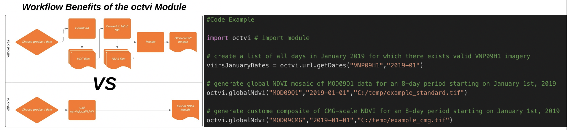
There are challenges associated with pulling such large amounts of data from the source, which is why the octvi system is particularly useful. It is not only able to download the imagery directly from the satellite sensors but also has the functionality to mosaic the imagery based off of user specifications into a single global image. Since octvi’s inception, O’Neill has expanded its imagery products from 8-day vegetation indices to 16-day vegetation indices as well as integrating user manipulated multi-day composites. Furthermore, the octvi software is free to use and completely open-source, allowing all use to access and modify the software according to their needs.