Locating Unexploded Ordnance in Ukraine Using Satellite Imagery
Conflict produces a number of immediate and long-term consequences for impacted land and populations. Unexploded ordnance (UXO) is one of the longest-lasting threats in conflict zones as it can remain a potential threat for decades after its initial deployment. The Russian invasion of Ukraine is not an exception to this with the Ukrainian government estimating up to a third of the country to be contaminated with UXO. Researchers with the NASA Harvest consortium are developing new automated methods to detect artillery craters and assist with the identification and removal of UXO in Ukraine.
Russia has made heavy use of ballistic and rocket artillery during its war with Ukraine. Many of the munitions used are from older military stocks and thus more likely to not explode upon impact. These unexploded munitions then become buried over time and pose a significant risk to those who stumble across them in the future. In heavy agricultural lands, where soil disturbing activities like plowing happen regularly, there is a heightened risk of accidental activation of UXO. This risk makes the successful identification of likely UXO of paramount importance.
Satellite imagery showing large number of artillery craters east of the city of Bakhmut in the Donetsk oblast in eastern Ukraine. Photo was taken January 2023. (c) Maxar.
Developments in very high resolution (VHR) satellite imagery have allowed objects to be identified at a sub-meter resolution (~30-50 cm) meaning that UXO can be detected with significantly less risk and time compared to traditional methods like field surveys. Given the large areas of land that must be investigated however, automated detection models are needed to help process large amounts of satellite imagery quickly.
While UXO itself is very hard to impossible to detect even with using VHR satellite imagery as the individual ordnance is unlikely to be viewable, even before it is buried. Using knowledge of Soviet and post-Soviet military doctrine, the research team determined that artillery craters could provide a sufficient proxy for UXO. Knowing that unguided artillery is often fired in bursts from a single location, the team knew that the artillery will land in a concentrated landing zone, meaning that UXO, if it exists, is likely to be contained within the crater left behind by the artillery burst.
Given that the craters themselves can also degrade over time, becoming filled with vegetation and looking like normal parts of the landscape, it is important to identify these craters when they’re formed so they are able to be properly investigated later. Providing a map of crater locations can help speed up and make more efficient the process of checking the landscape for UXO.
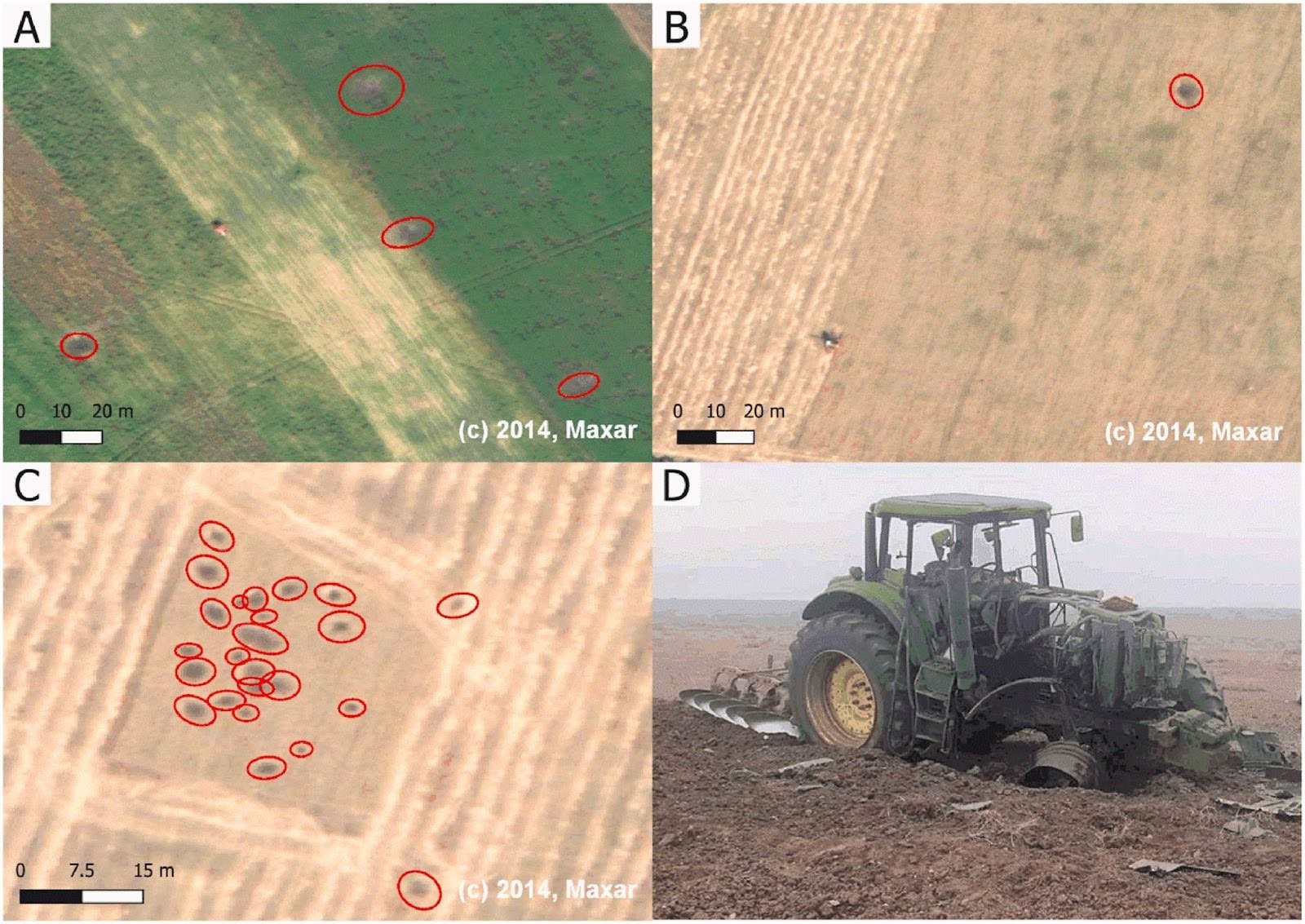
Examples of continuing agriculture work in agricultural fields which have been hit by artillery. (A) A tractor likely cutting hay in the close vicinity of artillery craters. (B) Harvest of a field, with nearby craters. (C) A harvested field, in which the farmer has avoided the patch of multiple craters, likely fearing the presence of unexploded ordnance (UXO). (D) A tractor that set off a UXO in Ukraine while plowing. (c) Maxar.
Examples of the reference (manually labeled) and detected craters by the research team’s model. In this example, the detection success between multiple groundcover variations can be seen, with correct detections in both bare soil and green grass fields. (c) Maxar.
The research team developed a couple machine learning algorithms and compared their efficacy to quickly parse large amounts of VHR satellite imagery and locate artillery craters. Their best-performing model was able to identify 22,000 craters within a selected study zone in eastern Ukraine.
Previous research shows that crater sizes can range from 10-30 m2 to more than 500m2. The authors noted that the model works best on craters that were 60m2 or larger. Craters of that size were 68% of all labeled craters in the study site, indicating that this model is very useful for identifying large portions of artillery craters from the conflict.
“This work shows how state-of-the-art technologies in Earth observations from space and remote sensing coupled with advances in image processing can be used for societal benefits, specifically identifying the areas of the high likelihood of UXO presence and potentially assisting de-miners with prioritization and resource optimization”, said Sergii Skakun, NASA Harvest researcher and co-author of the paper.
The original study is open access to the public and can be read in its entirety here.


